
DEVELOPMENT MILESTONES
DOCUMENTING CONSTRUCTION PROGRESS WITH AERIAL DATA
Aerial drone documentation has become a standard practice in construction project management, with developers, general contractors, and project stakeholders using high-resolution imagery and 3D models to track milestones, verify work completion, and maintain accurate records. These UAS platforms capture consistent overhead views, generating weekly or monthly orthophotos, stitched orthomosaics, and 3D models that provide clear visual evidence of site advancement over time.
Skyline Aerial Solutions specializes in collecting and processing aerial data—high-res RGB imagery, georeferenced orthomosaics, and photogrammetric 3D models—to support project documentation. This data assists teams in creating progress reports, comparing phases, identifying deviations early, and fulfilling contractual or stakeholder requirements without relying solely on ground photos or manual surveys.
FAA Part 107-certified pilots conduct safe, compliant flights at regular intervals, delivering consistent, repeatable datasets that integrate into project management tools, BIM software, or reporting packages.

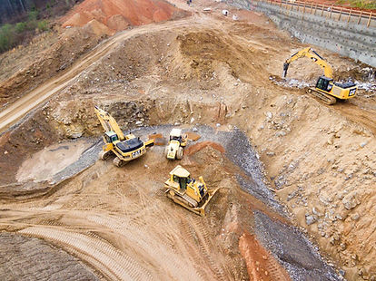
APPLICATIONS
WEEKLY OR MONTHLY ORTHOPHOTO UPDATES
High-resolution RGB orthophotos capture the entire site from consistent altitudes and angles, creating a visual timeline of progress. Weekly or monthly flights document milestones such as foundation completion, framing stages, roofing installation, or landscaping. These images support progress reporting, stakeholder updates, and early detection of schedule deviations—ideal for developers tracking multi-phase projects or contractors verifying subcontractor work.
STITCHED ORTHOMOSAICS & MEASUREMENTS
Stitched orthomosaics produce accurate, georeferenced 2D maps of the site for approximate measurements of built areas, material stockpiles, earthwork volumes, or footprint changes. These maps enable side-by-side comparisons across intervals, quantifying advancement (e.g., square footage completed, cut/fill balances) and providing defensible records for payments, change orders, or disputes.
3D MODELING & PHOTOGRAMMETRIC TIMELINES
Photogrammetric 3D models generated from overlapping images create interactive digital twins of the project at each milestone. These models visualize elevation changes, structural alignment, and overall form, allowing stakeholders to review progress virtually, measure volumes, or simulate future phases. Exports support BIM integration, progress animations, or stakeholder presentations—particularly useful for large-scale developments or complex sites.
REMOTE MONITORING
Live aerial feeds and real-time monitoring sessions enable off-site stakeholders to observe site conditions, progress, or specific areas without physical presence. Secure streaming delivers high-res RGB views directly to teams, clients, or investors—allowing interactive requests for targeted angles, zooms, or annotations during the flight. This supports immediate decision-making, rapid issue resolution, and virtual site walks, especially useful for multi-party coordination or when weather, access, or scheduling limits on-site visits.
Learn more about Remote Monitoring
BENEFITS FOR YOUR TEAM
-
Accurate Progress Tracking — Consistent aerial data provides objective, timestamped records of milestones, reducing disputes and supporting billing/payment applications.
-
Early Issue Detection — Regular orthophotos and models reveal deviations, rework needs, or safety concerns before they escalate, saving time and costs.
-
Enhanced Reporting & Communication — Visual timelines and 3D views improve stakeholder updates, client presentations, and marketing materials.
-
Efficiency & Cost Savings — Cover large sites quickly with minimal disruption, eliminating the need for extensive ground surveys or manual photography.
-
Compliance & Documentation — Georeferenced deliverables meet requirements for permits, financing, or quality assurance, with repeatable baselines for long-term projects.